Driver hits and flips a baby in their stroller: The status quo at Otis Drive and Mound Street
Alameda's plans for improving traffic safety are guided by crash statistics. The intersections where there have been a disproportion number of fatal and serve crashes are identified as high-crash intersections, and the streets where there have been a disproportion number of fatal and serve crashes are identified as high-injury corridors. Crashes that results in death or severe injuries — injuries that are "life altering" in that they will forever change the victim's life physically or cognitively — are weighted of more importance. The high-injury network that is identified by this analysis is very useful for helping the City of Alameda to focus its constrained resources on where efforts to improve traffic safety will likely reduce the most risk for all roadway users. It's a methodical, if dispassionate, approach.
But sometimes crashes can be meaningful signals and reminders to take action, even if they don't kill anyone or leave anyone permanently impaired.
A driver hits pedestrians at Otis and Mound
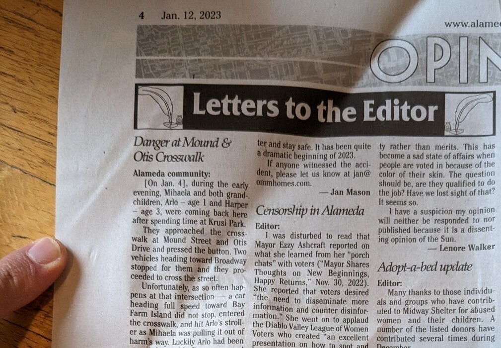
Here's a letter to the editor in a local newspaper describing a recent crash:
[On Jan. 4], during the early evening, Mihaela and both grandchildren, Arlo – age 1 and Harper – age 3, were coming back here after spending time at Krusi Park.
They approached the crosswalk at Mound Street and Otis Drive and pressed the button. Two vehicles heading toward Broadway stopped for them and they proceeded to cross the street.
Unfortunately, as so often happens at that intersection — a car heading full speed toward Bay Farm Island did not stop, entered the crosswalk, and hit Arlo’s stroller as Mihaela was pulling it out of harm’s way. Luckily Arlo had been strapped in with five straps and although he was turned upside down, his head did not hit the pavement.
The driver planned to leave, but one of the drivers of the stopped cars had already called 911 and the police, ambulances and fire department showed up within minutes. The police stopped the driver from leaving. A report was taken, the children and Mihaela were checked out and they suggested she take Arlo to see a doctor that day.
We were all upset beyond belief! The family had a restless night, Harper woke early — scared and has fears about the incident. Mihaela is shaken. And now the process begins for healing the trauma.
Many neighbors have had bad experiences at that intersection. I have almost been hit three times. We hear screeching brakes all the time and nothing changes. Last night, the pedestrian lights were not working. I wanted to get this information out to you for your safety. But we also need to get some action from the city government to come up with a safer plan for this area. We need to somehow get Alameda Police Department to stop Otis from becoming such a death trap.
I will be preparing a letter to the city and hope we can all sign this request for immediate action from those who claim to have pedestrian safety as their top priority. If you want to send me an email sharing your concerns or have any suggestions on how to make this area safer for our children, pets, and ourselves — I welcome it and will work diligently to get some changes made with the city.
Thank you for reading this letter and stay safe. It has been quite a dramatic beginning of 2023.
If anyone witnessed the accident, please let us know at jan@ommhomes.com.
— Jan Mason
[Alameda Sun, letter to the editor, January 12, 2023, headlined Danger at Mound & Otis Crosswalk]
I cringed while reading this letter. Having kids has made me realize how hard — physically hard — of a place this world is. So much concrete to tumble onto... so many corners to get poked by. My own kids are now a bit older and bumps are less of an around-the-clock concern. Still, I've gained more appreciation for how unyielding aspects of our world are for little ones (not to mention also seniors and people of differing physical abilities).
It's great to hear that the child was not physically injured — that this will not be added to the statistics in the death or severe injury columns. But the fact that a baby's stroller was hit by a driver and that medical personnel had to come to check on the baby's health mean this was still a huge worry for this family. And it should be an urgent call-to-action for the public agencies involved in managing this stretch of Otis Drive.
Another crash on Otis
This stretch of Otis Drive has had other crashes in the past. Robert W. Crown, Alameda's state assemblymember, was killed by a driver while he was crossing Otis nearby on foot:
Crown died in the early morning hours of May 21, 1973, after being struck by a car while jogging across Otis Drive at Fountain Street. The driver, Charles Shuler, hit Crown after going around a car that had stopped to let him pass. Crown died hours later at Alameda Hospital after suffering head injuries, a fractured pelvis and massive internal bleeding.
An eyewitness who knew Crown told the Times-Star that Crown "often jogged by himself for fitness at all hours of the day” and that he was wearing bright white track clothes when he was hit. Many neighbors, including the city’s soon-to-be-mayor, Chuck Corica, reportedly ran out when they heard the crash.
— "Alameda in History: Assemblyman Robert W. Crown" by Michael Lano in The Alamedan, February 27, 2015
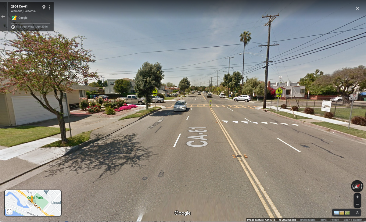
Four lanes is two too many
In the 1973 and 2023 crashes, a similar set of conditions appears: In some of the four thru lanes, drivers stop to let pedestrians cross, while a driver in each case sped ahead in one lane, oblivious to the crossing pedestrians.
Two separate aspects are worth considering more:
- the challenges for pedestrians to cross four thru lanes of auto traffic
- the speed of the drivers who were at fault
Let's take the second issue first. The driver's speed is the "proximate problem." If the driver in 1973 were going more slowly, they would likely have injured rather than killed Crown. If the driver in 2023 were going more slowly, they would have been able to brake before hitting the child's stroller — even after disregarding or not seeing the flashing crossing lights. Slower speeds give drivers more time to respond to the unexpected; slower speeds give pedestrians and cyclists significantly higher chances of surviving collisions.
Now, the first issue: the "ultimate problem" is why these types of crashes are occurring to pedestrians along this stretch of Otis Drive. Four travel lanes of traffic are too many for drivers to predictably stop for pedestrians at uncontrolled intersection.
Uncontrolled intersections (where there is no stop sign or traffic light) across multiple thru lanes are a challenge for both pedestrians and drivers. Drivers may not be able to see pedestrians who are occluded by other cars (as in the case of the 1973 crash). Wider roads also encourage drivers to go about the posted speed limit (probably a factor in both crashes) and provide speeding drivers the option to change lanes around other drivers who are respecting the speed limit. For pedestrians trying to cross, it's an open question of when it's actually safe to cross: when one approaching car stops? when cars stop in all lanes?
In the 50 years between the 1973 crash and the 2023 crash, Caltrans installed flashing pedestrians lights. These Rectangular Rapid-Flashing Beacons (RRFBs to a traffic engineer) can help with one of those challenges: the situation where one stopped car occludes crossing pedestrians. Drivers in all lanes can see the RRFBs flashing. But it still requires attention and respect on the part of drivers. Pedestrians trying to cross still face the same dilemma of knowing when it's truly safe to cross.
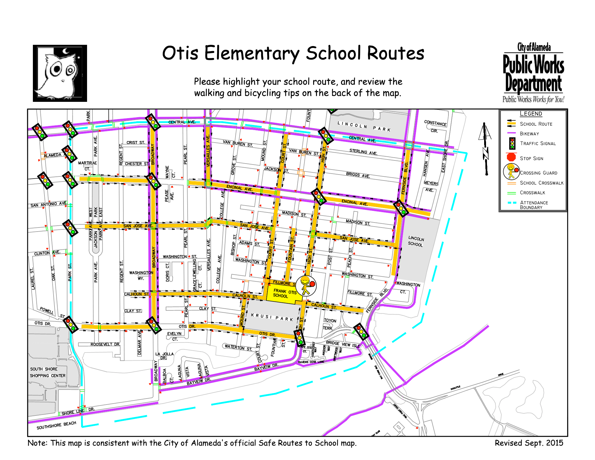
Four lanes is definitely two too many given the location of this corridor: Otis Drive runs alongside a park and an elementary school. The crosswalk at Otis Drive and Mound Street is identified as a route to the elementary school as part of the county and city's safe routes to school program:
Pedestrians' Rights and Duties
Neither of these crashes should be happening. According to the California Vehicle Code, pedestrians have the right-of-way at all intersection crosswalks:
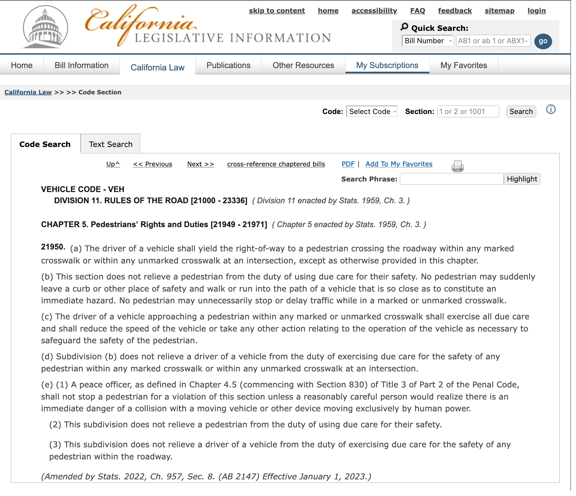
The crosswalk doesn't even have to be marked with paint, let alone with flashing lights, for pedestrians to have the legal right-of-way to cross and for drivers to have the duty to slow and stop for them. The driver at fault in 2023 should have stopped.
If one driver has already stopped at a crosswalk to let a pedestrian cross, all other drivers behind them — whether in the same lane or other lanes — must also stop:
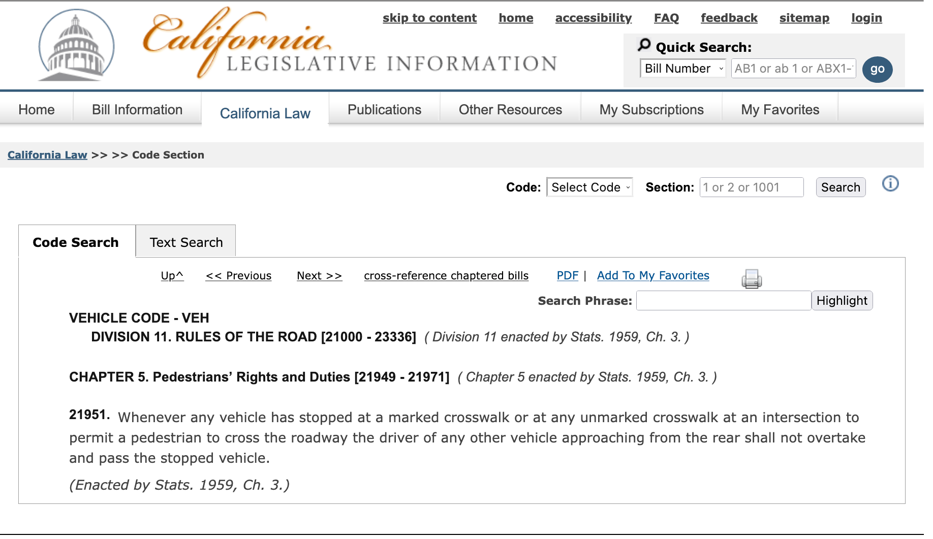
The driver at fault in 1973 should have slowed and stopped.
Road diets
The "pedestrians' rights and duties" section of the California Vehicle Code sounds grand — but it just doesn't match the "on the ground" reality of many actual streets.
The good intentions of the California Vehicle Code can't stop what a straight four-lane road like Otis Drive is encouraging a driver to do: speed, change lanes around slower cars, ignore pedestrians on the wayside...
It's well past due that this stretch of street be made safer for pedestrians using the best practices of today: a "road diet."
In recent years, another stretch of Otis Drive have been successfully reduced from four to two auto lanes: the portion between Willow Street and Westline Drive where Otis Drive terminates at Robert W. Crown Memorial Beach (instead of fixing the road where he was killed, they named the beach at the end of the road after him).
The portion of Otis Drive from Broadway west to Park Street has a similar configuration of one thru lanes of auto traffic in each direction and a shared center turn lane.
Drivers who feel the need to weave back and forth between lanes to overtake slower drivers are probably angered by the road diet'ed sections. For all other roadway users — drivers included — it's an improvement.
When using the narrow "Level of Service" approach used by traffic engineers to assess delays for drivers, it's the intersections along Otis Drive that continue to be the slow spots. Reducing the lane counts between the intersections does not introduce new significant delays. Rather, it helps to smooth out the experience of driving along the entire corridor.
Recall the letter about the 2023 crash:
Unfortunately, as so often happens at that intersection — a car heading full speed toward Bay Farm Island did not stop, entered the crosswalk, and hit Arlo’s stroller
This sounds like a driver who may have gotten pissy while waiting at the Otis/Broadway intersection who wanted to "make up time" by speeding and ignoring the flashing lights at Mound. A slimmer road would better constrain this type of speeding and put the "pedestrians' rights and duties" into more concrete action.
Who's in charge?
This stretch of road has two names: Otis Drive and State Route 61. As a part of the state highway system, this portion of roadway is owned by the California Department of Transportation (Caltrans) and managed by Caltrans District 4 (which manages state highways across all nine counties of the Bay Area). It's Caltrans D4 in Oakland that decides what happens on this portion of Otis.
The City of Alameda is requesting that Caltrans redesign it with a "road diet" similar to the city-owned portions of Otis:
Broadway/Otis Drive/Doolittle Drive Pavement Resurfacing and Safety Improvements
In 2024, Caltrans will construct the pavement resurfacing, and currently is considering safety improvements to be included in this project, which extends from Broadway at Encinal Avenue to Doolittle Drive in Oakland. City staff requested Caltrans to restripe Otis Drive and Doolittle Drive as a road diet with a bikeway and to consider sea level rise adaptation measures.
—City of Alameda Annual Report on Transportation, January 2022 (p. 34)
Caltrans has successfully reduced other portions of SR 61 to one thru lane in each direction (along Broadway) and will soon start similar construction on another long stretch (along Encinal). The auto lanes are still quite wide — wide enough for semi trucks, which does encourage drivers to speed — but at least the single thru lane prevents drivers from racing around each other. The experience for pedestrians crossing the street is much improved. There is no longer so much uncertainty at each crosswalk of how many lanes of auto traffic will fully stop for pedestrians waiting to cross.
Caltrans should do the same type of "road diet" by reducing Otis Drive to two auto lanes between Broadway and High Street.
A road diet would finally address the stretch of roadway where Robert Crown was killed. A road diet would help to turn the crosswalk where a driver hit and flipped a baby's stroller into a place that's more predictable and safer for pedestrians to cross, where the physical design actually guides drivers to obey CVC §21950 and CVC §21951.
Assembling info on crashes
Thanks to the family that wrote this letter to the editor describing the 2023 crash, those of us who care about traffic safety in Alameda have more information to work with. It's both more vivid and immediate than the official sources.
CHP collects crash reports from law-enforcement agencies around the state in the SWITRS database, which are georeferenced by the SafeTREC center at UC Berkeley and can be queried and visualized using the GIS map in their TIMS tools. [How many acronyms can I squeeze into that single sentence?] But there's a typical lag time of over a year for crash reports to make their way through all those systems. And this only accounts for crashes in which police came out and prepared reports.
In the case of the 2023, police and paramedics were called, and it will eventually add a records to SWITRS, TIMS, etc. The good news is that record will likely be classified with the lowest level of crash severity. The bad news is that such a harrowing experience will just be an increment in the lowest level of crash severity.
Let's run a query and see what other stats this latest crash will join: 18 total crashes between 2011 and 2021.
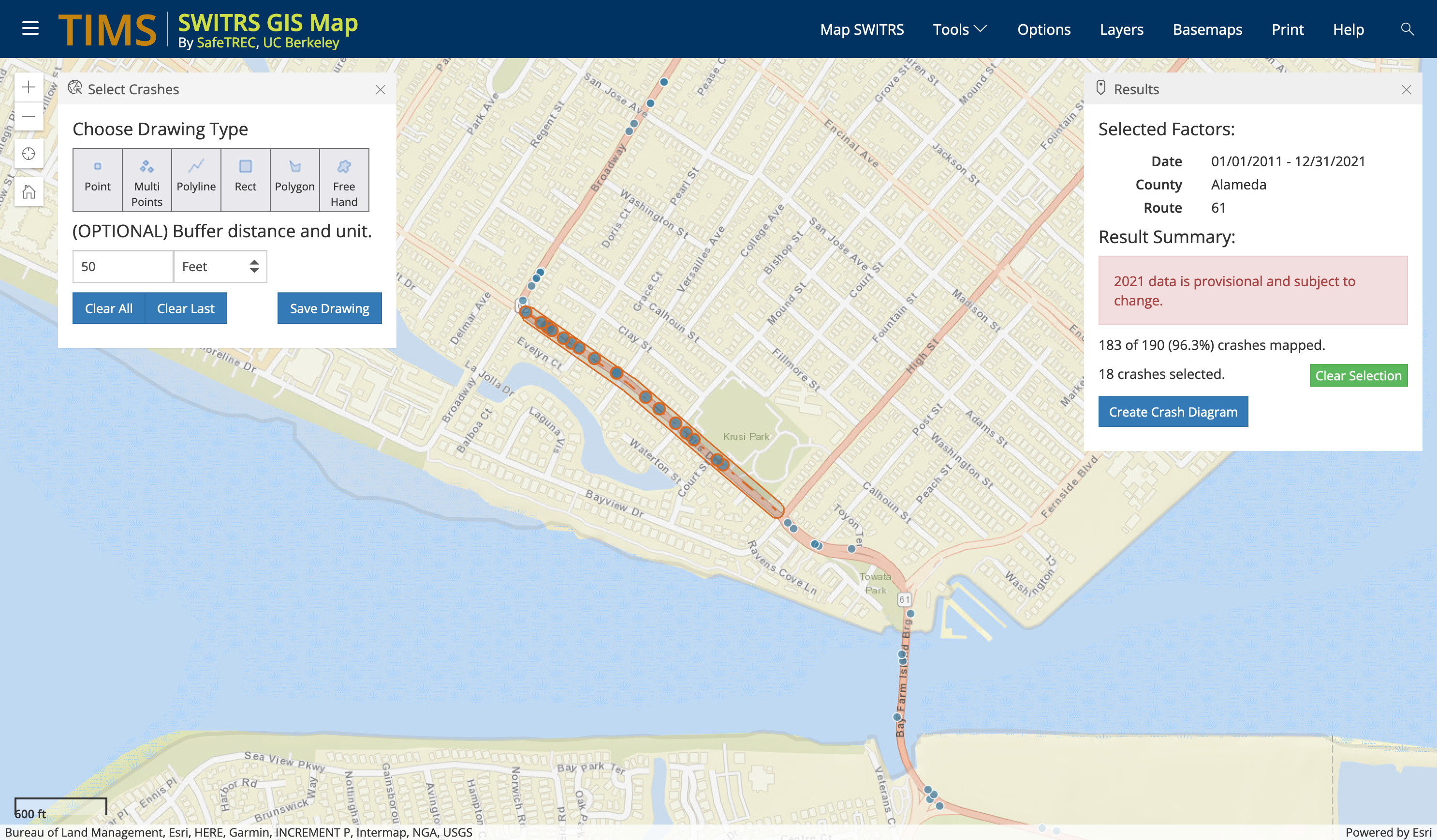
The most common "primary crash factor" (as judged by the police officer filing the report) was unsafe speed:
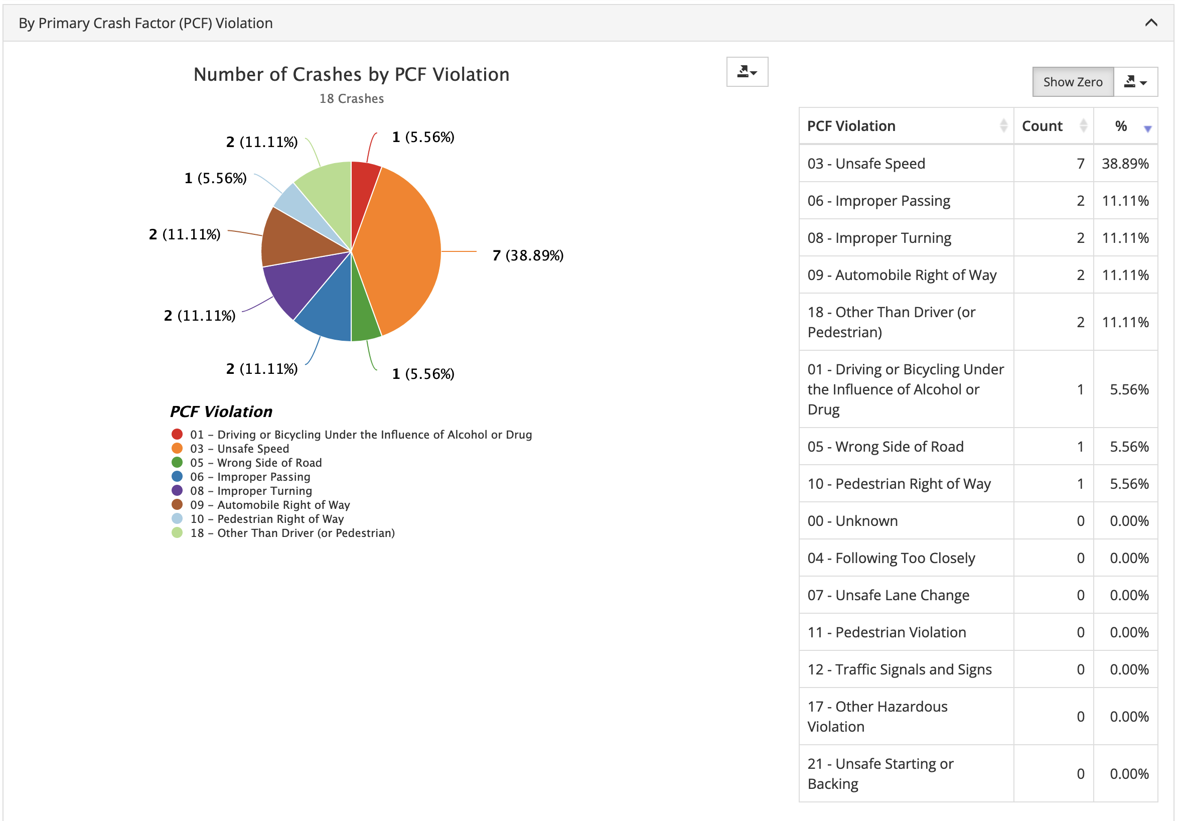
Of the 18 total crashes, 3 were vehicle-on-pedestrian crashes. In all 3 situations, the driver was deemed at fault by the police report:
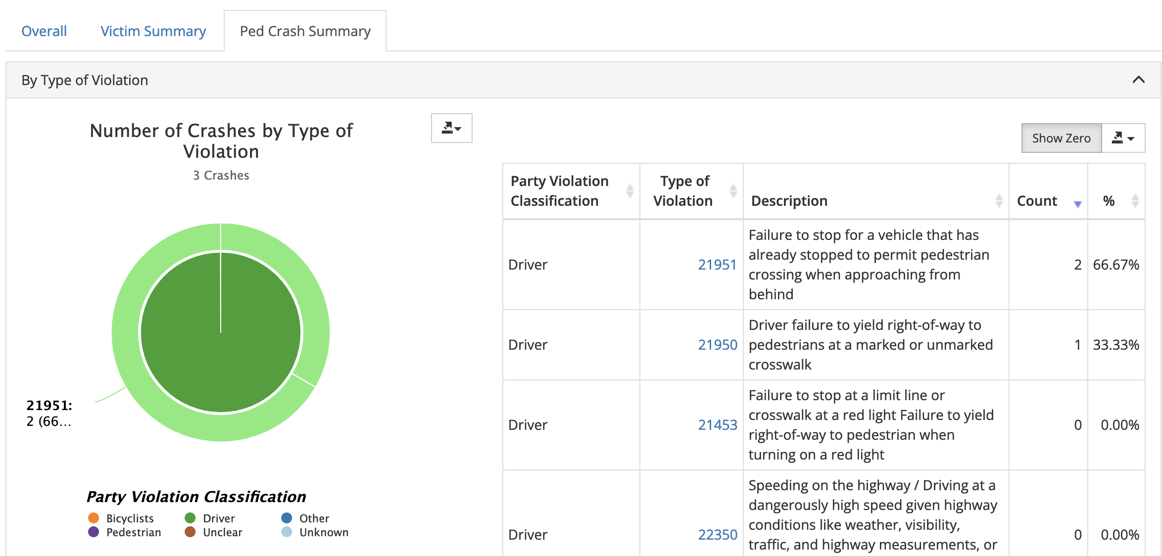
In 2 of the crashes injuring pedestrians, the driver who was at fault didn't stop when they saw another driver already stopped at a crosswalk (CVC §21951 violation; like the 1973 crash killing Robert Crown).
In 1 of the crashes, the driver who was at fault didn't stop for the pedestrian who had the right-of-way (CVC §21950 violation; like the 2023 crash flipping the baby's stroller).
Each of these crash reports likely has a similarly harrowing story behind it.
One is too many
A thorough analysis requires also comparing these crash numbers against the total usage. What matters to transportation engineers and planners is not the absolute number of crashes but instead the relative number. If a lot of people drive on a road, then a couple crashes may be the cost of doing business. (According to Caltrans counts from 2017, a typical weekday sees 10,400 cars driving in one direction at Otis/Broadway 24,300 in the other direction.) If many pedestrians cross at this point and the vast majority are not hit, then it's better than it could be. (Caltrans does not publish aggregated counts of pedestrians or cyclists on state highways.)
And yet that letter to the editor reminds us that one crash is too many.
And Robert Crown's death in 1973 is a reminder that one crash is too many. The article I quoted before also hints at the work Crown left unfinished as a state assemblymember:
When he died, Crown was head of the Assembly’s seven-person Criminal Justice Committee, which was set to begin hearings on use of the death penalty in California. He was part of a four-person bloc of legislators who opposed the death penalty, and would have been a swing vote to prevent it from being employed in the state.
— "Alameda in History: Assemblyman Robert W. Crown" by Michael Lano in The Alamedan, February 27, 2015
This is the reason why we have a "Vision Zero" program in Alameda — to reduce the number of injuries and deaths on roadways to zero. Yes, reaching zero means running the stats and working incrementally downwards. But reaching zero also requires clear priorities when opportunities arise to make safety improvements.
Caltrans is planning to redesign and repave this section of Otis Drive in 2024. When they redo it, they should do it right — so that no more babies are hit and flipped into the air by speeding drivers.
Note: I updated this post to add a "call to action" at the end. I also corrected a my comments on the section of Otis Drive between Broadway and Park Street — that portion of city-owned road was recently resurfaced with new lane markings. However, the resurfacing didn't reduce the overall lane counts — it wasn't a "road diet." Since at least the 2008, Google Street View shows two total travel lanes and a shared center turn lane.